![]()
![]()
![]()
![]()
|
|
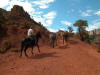
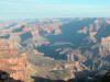
Grand Canyon National Park The watchtower (at Desert View) Large circular painting The Colorado River seen from the Watchtower observatory. The Colorado River seen from the Watchtower observatory. The Colorado River seen from the Watchtower observatory. Navajo Point Lipan Point Kolb Studio (at Grand Canyon Village) El Tovar Hotel The Hopi House Bright Angel Trail The Orphan Mine. Hermits Rest Hermits Rest Indian Gardens Cedar Ridge Hike (with Ranger Haley) Cedar Ridge Canyon view from Cedar Ridge Mather Point "Build a structure that provides the widest possible view of Grand Canyon yet harmonizes with its setting": this was architect Mary Colter's goal when the Fred Harvey's Copany hired her in 1930 to design a gift sho and rest area at Desert View. Colter's answer was the Watchtower. It tells the Snake Legend - the story of the beginning of the Snake Dances. It is also the story of the first man to navigate the Colorado. Colorado River : - depth : an average of 35 ft (11 m) - width : from 76 ft to 300 ft (23 to 90 m) - volume : usually between 30,000 cubib feet per second (28 to 850 m3) - length : 1468 miles Upstream, Glen Canyon Dam controls river volume as water is released from Lake Powell. The demand for electricity as far away as Los Angeles can determine the amount of water that is released. Geology : to form the Grand Canyon, the Colorado River cut through one mile of rock layers. The canyon's upper rocks formed from sediment deposited in ancient seas, swamps and deserts. The lowest (and oldest) rocks formed from deep within the earth's interior. In some areas, relatively recent volcanoes have played a part, too. Although rocks exposed in the canyon are hundreds of millions of years old, geologists believe the canyon itself is less than 6 million years old. Canyon length: 277 miles from Lees Ferry to the Grand Wah Cliffs. The canyon is bounded by two great dams and the lakes they contain : Glen Canyon Dam and Lake Powell upriver, and Hoover Dam and Lake Mead downriver. Begun in 1904, this house, built on the brink of the Grand Canyon, was the home, photographic studio and lab of pionneers Emery and Ellsworth Kolb. They secured a prominent place in Grand Canyon history in 1912 with the completion of a boat trip down the Colorado River. Though not the first to dare the rapids, the Kolbs were the first to record their adventures on the river with a movie camera. designed by architect Mary Colter. The tiny spots you can see on the trail are... mules ! In 1951, geologists discovered that the Orphan Mine was rich with uranium, and the mine's heyday began. In the 1950s, the mine - ironically within a national park - became America's richest source of uranium. At that time, silver and vanadium were also dicovered. But by 1969, the high grade ore was mined out and mining ceased. In 1988, the National Park Service gained ownership and the Orphan Mine's mining days ended for good. Climate : it differs dramatically between rim and river. Temperatures on the rim are usually about 30°F (17°C) colder than at the river. Each year about 15 inches (38 cm) of moisture fall on the South Rim ab=nd 25 inches (64 cm) fall on the North Rim. But only 8 inches (20 cm) reach the canyon floor. The rim supports a cool forest; the canyon depths contain hot dry desert. Width : about 10 miles in a direct line from rim to rim, 24 miles by hiking trail and more then 200 miles by road. Going down the canyon half-way on the South Kaibab Trail. Mules going up and down Cedar Ridge Trail to pave it thanks to the stones they carry on their back.
")
The watchtower (at Desert View) "Build a structure that provides the widest possible view of Grand Canyon yet harmonizes with its setting": this was architect Mary Colter's goal when the Fred Harvey's Copany hired her in 1930 to design a gift sho and rest area at Desert View. Colter's answer was the Watchtower. |
|
|
")


")


")